|
Via Michelin X-930 GPS
Navigation Unit
Small and compact, but disappointingly
underfeatured
|
|
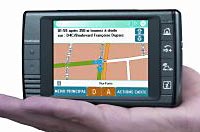
The Via Michelin X-930
is small and compact, but note the wasteful use of screen
space, leaving very little room for the actual map itself. Part
of our series on GPS - additional articles to be
published in coming weeks. |
The Via Michelin X-930 GPS receiver
promises to be an appealing unit at a great price. But,
this promise is massively broken. The unit suffers from
irrational and inexplicable limitations and problems. It
is difficult to understand and use, and not nearly as flexible
as other units.
Accordingly, this unit is a
poster child example of how a unit can look great on paper (and
get good generic reviews from reviewers who apparently have done
nothing other than read the press release) but which is
completely unsuitable for normal people and normal uses.
Not recommended. If
you're looking for a small size low price unit, choose the
vastly superior GlobalSat GV-370
instead.
Via Michelin X-930 Overview
Michelin are best known for
their travel guides, books that enjoy a very high quality
reputation. They moved into offering GPS receivers in
Europe a couple of years ago and are now expanding into the
North American market.
The X-930 went on sale in
the US in December 2006. It has already been superseded in
Europe by first the X-950 and subsequently the big screen X-980, but these newer units
are not yet (March 2007)
available in the US.
At first blush, the X-930
has a lot going for it. It comes from a respected
supplier; it is small and lightweight, and has an acceptably
large 3.5" screen. Best of all, its list price of $299 has
been discounted to $199 by Amazon, making it - in terms of price
- one of the very best value units currently being sold.
But this unit is a classic
example of how a unit that looks good on paper massively
disappoints in real world testing. Its user interface is
obtuse and difficult to follow, and much of the screen is wasted
with unnecessary and overly large data.
Programming is difficult,
and unlike many competing units, simply using it to show you where you are is not a default
action, but instead requires you to work through five layers of
non-intuitive menus.
The design of the maps is
also poor, with roads at certain scales being shown as thin
orange lines against a lighter orange background. This
makes them almost completely invisible!
And, talking about scale,
you have no way of knowing what scale the map is being displayed
at. Does an inch on the screen represent 100 feet or 100
miles? Regrettably, we're not told that important
information.
There are plenty of other
quirks and failings, too. For example, we can't get the
unit to show our direction, in a straight line along a road, as
a straight vertical line on the screen (as is uniformly the case
with every other unit we've ever seen). Instead, it is
displayed as a slanting line from the bottom left part of the
screen to the top right part of the screen. When we called
and asked Via Michelin's help desk about this, they variously
didn't know what we meant, couldn't explain why the path was
oriented that way, and were unable to fix the problem.
Using the Unit
The unit turns on and off
instantly which is nice, and doesn't treat you to any warning
screens about using the unit carefully when driving, which is
even nicer still.
The unit had good
sensitivity to satellite signals, even inside the vehicle with
no external antenna, with at times as many as ten satellites
being locked on. But it sometimes took five minutes or
more to get a 'lock' on sufficient satellites as to know where
it was and be able to start helping you with directions - this
is way too long; imagine having to wait five minutes or longer
before being able to start your journey. This is longer
than other units, but might be reduced
if you added an external antenna.
The screen is crisp and
clear, but as soon as we confronted the main screen we found
ourselves reaching for the manual. The three options
offered - 'Navigate to', 'Plan your journey' and 'Settings' were
confusing when all we wanted to do was display the map and see
where we currently were.
To get the unit to do this
basic function, we had to follow this complicated sequence :
1. Choose 'Plan
your journey'
2. Choose 'Display a Map'
3. Choose 'Map Options'
4. Choose 'Center Map'
5. Choose 'on GPS position'
This is completely
counter-intuitive. The difficulty in mastering the unit is
compounded by having sometimes strange symbols rather than names
on the buttons on the front of it. All in all, we could
never adequately understand how to get the best use out of the
unit. Sure, we could have committed ourselves to an
intensive course of study and practice, but that would not help
us if we then didn't touch the unit for three months, because
we'd for sure forget everything about the unit in the meantime
and have to relearn everything once more.
This poorly designed
interface is aggravated further by Via Michelin's penny pinching
decision not to include a manual with the unit. You have
to go online and download a copy from their website instead.
In terms of actually using
the unit, it suffers from significant drawbacks in that area,
too. As the picture at the top of this page shows, about
half the screen is used for various informational displays,
leaving only a slim narrow band in the middle for the map.
This is regrettable for two reasons - firstly it is a shame to
waste so much valuable screen on this information, and secondly,
when you're using the unit, most of the time you're interested
in what is ahead of you, rather than what is on either side of
you. If Via Michelin really did need to use parts of the
screen for the other information, it should do this on the
sides, not on the top and bottom.
And for a really illogical
arrangement, if you have the unit simply showing where you are
on a map, the map is fixed in a north up direction - most of the
time you'd want it to be in a 'direction of travel up' direction
instead, but when you have the unit set to direct you somewhere,
it switches into the direction of travel up mode. Unlike
most other units, it is impossible for you to change directional
modes yourself.
Most people use their GPS in
what I'd call 'active' or 'passive' modes. In active mode,
they have programmed in a destination and are using the GPS to
guide them to that destination. In passive mode, they are
just using it as a moving map to see where they are. This
unit works acceptably (but not excellently) in active mode, but
in passive mode it is very disappointing, showing little
information on the screen.
In active mode, the unit was
sometimes struggling to give us turn information ahead of when
the turn appeared on the map, and unlike many units, it didn't
clearly highlight exactly where and how to make turns.
There are problems and
poorly thought out issues with many different parts of this
unit's operation. One other thing we really disliked was
the lack of a scale on the map. We had no way of knowing
if the scale as zoomed in or out, and by how much.
Recalculating directions was
automatic, and moderately fast, but not as quick as some units
we've used.
For some strange reason, the
unit decides that you've reached your destination way before you
have. Sometimes I could be five miles away from the
destination and the unit switches from turn by turn guidance to
triumphantly telling me I've arrived. Wrong.
The Bottom Line
Much as we wanted to like
this unit, we feel it to be a frustrating waste of money with no
redeeming features.
You're much better advised to buy a unit with a more
user-friendly interface and better laid out map and screen
graphics.
Feature Analysis
|
Feature |
Test
Unit |
|
Model |
Via
Michelin X-930 |
|
Price |
$299
list, $199 at Amazon |
|
Review
Date/Details |
Tested
March 2007.
Version 5.0.0-AMN - Build 36 software in the
test unit |
|
Warranty |
One year |
|
Support |
Via
Email or (800) number 9am-7pm M-F EST.
Two test calls to phone support revealed
short hold times, with one unskilled and one
very helpful support
person. |
|
Inclusions |
The unit
comes complete with most things you'd need :
The unit itself
Windshield mounting bracket
Dash mounting adapter
Mains power adapter
Car power adapter
USB cable to connect to a computer
1GB SD card with US map preloaded
DVDrom with US and Canada map data
Quick
Start guide in English and French
The unit does not have any type of carry
case and neither does it come with an
external antenna. |
|
Runs out
of the box |
Yes, all
you need to do is insert the SD card, turn
it on, answer four or five easy
configuration questions, and the unit is
then immediately ready for use.
Warning
- the unit might be ready for use, but
you'll need to spend some considerable time
learning its quirks before you can
effectively use it! |
|
Size |
Unit
measures 2.8" x 4.7" x 0.7".
The mounting adapter is a large ungainly and
heavy device. |
|
Weight |
unit by
itself = 5.0 oz
unit, mounting device, power cable = 15 oz. |
|
Mounting
Accessories |
A rather
ungainly looking mounting bracket can be
affixed to the windshield with a very strong
suction cup or to to dashboard with an
adhesive mounting plate. |
|
Screen
Size |
3.5"
diagonal
2.25" x 2.85" = 3:4 aspect ratio |
|
Screen
Pixels |
240 x
320 pixels
106 pixels/inch vertically
112 pixels/inch horizontally |
|
Screen
Colors |
|
|
Screen
Visibility |
Fair.
Screen is reasonably bright, but colors are
poorly chosen (eg bright orange streets on a
pale orange background). |
|
Screen
Backlighting |
Yes,
multiple levels offered. |
|
Day/Night Mode |
Manual
switching between day and night modes, which
includes an automatic dimming/brightening of
the screen.
Colors change as part of the mode change. |
|
Controls |
The unit
has two volume buttons on the left, four
'main menu' type buttons on the right, an
on/off switch on the top, and a SD card lock
switch, also on the top, which prevents the
unit from writing data to the SD card. |
|
Interactive help files available |
No |
|
Limited
functionality when moving |
No |
|
Graphics
processor speed |
Fair |
|
GPS
Receiver |
SiRF Star III |
|
Max
number of satellites simultaneously tracked |
12 |
|
WAAS
enhanced |
No |
|
Dead
reckoning capability |
No |
|
Satellite display |
Yes, but it only shows the satellites on a
bar chart, with each bar color and length
representing if the unit is locked onto that
satellite and the strength of the signal
being received. |
|
Accuracy
calculation |
No |
|
Can the
unit show you your current latitude and
longitude and compass heading |
Yes, on
the satellite signal screen |
|
Can the
unit show you your current altitude |
No |
|
Can the
unit show you the exact time |
No - it
can show you the time, but it doesn't seem
to synchronize its internal clock with the
satellite time. |
|
External
antenna capability |
Yes, has
a MMCX connector for an external antenna,
but Via Michelin don't sell external
antennas and didn't know if the unit
requires a powered or passive antenna. |
|
CPU
processor speed |
312MHz
processor with 32MB of RAM. This is
only moderately fast compared to other
units. |
|
Trip
Computer functions |
No.
It can be set to display instantaneous speed
in some display modes, but no other
information is available. |
|
Battery
Type |
Internal
lithium polymer. |
|
Battery
Life |
Said to
be good for 3 - 5 hours between charges,
depending on screen brightness. |
|
Power
Input |
Yes, it
has a mini USB port on the bottom of the
unit, which in theory allows it to be charged via any
external USB type charger, or to be powered
while working.
But, theory and reality yet again collide.
Bizarrely, the unit will only recharge when
you're using its own supplied power supply.
Yet another power supply to carry with you
on your travels.
Via Michelin could not explain why the unit
wouldn't recharge via any other usual USB
power source, and this is probably the
stupidest of the - alas, too many - stupid
features on this disappointing unit. |
|
Auto
Power On/Off |
No auto
on/off, but will switch off if no movement
for an extended period of time. |
|
Mapping |
|
Map
provider |
Navteq |
|
Countries provided |
US &
Canada - US on SD card, Canada on DVD rom
that needs to be copied to a SD card before
it can be used. |
|
Update
policy, frequency and cost |
Promise
annual updates, with the first due in late
fall/early winter 2007.
Pricing not set but will be discounted to
people who register their units. |
|
Other
countries also available |
Currently none; but have plans to add Europe
in the future |
|
How is
map data loaded into the GPS receiver |
Master information is on a DVD-rom disk,
information is loaded into the receiver via
an SD card. |
|
Can the
entire US be loaded into the unit |
The unit holds all of the US but not Canada. |
|
Speaks
Directions |
Yes |
|
Speaks
Street Names |
No |
|
Languages spoken |
English (American female), French, Spanish,
German, Italian |
|
2D/3D |
Yes |
|
Can you
choose between North up or Direction of
Travel up |
No.
Bizarrely, this unit doesn't have a
direction of travel up orientation; instead,
direction of travel is on a slant from about
bottom left up to about top right.
This is crazy and confusing. |
|
Split
screen mode |
No (and
screen too small to allow this, anyway). |
|
Map
scale shown |
No |
|
Number
of POIs provided |
more
than 1.5 million ViaMichelin qualified
Points of Interest that allow users to
easily find restaurants, lodging, gas
stations, banks/ATMs and other businesses
and services. |
|
Number
of user POIs that can be added |
Unknown |
|
POI
information includes phone number |
Yes for
pre-programmed POIs, apparently no for user
created POIs. |
|
POI
proximity alert |
Bizarrely, this is available when navigating
on a route, but not possible when simply
driving without a programmed destination. |
|
Speed
limit warner |
Yes, and
warns you based on speeds you set for six
different types of road you are on.
This is only moderately helpful, because, eg,
a city street might have a 25 mph limit in
one section and 35 mph in another. |
|
Does it
show both miles and kilometers |
Yes |
|
Route Planning |
|
How to
enter addresses and other data |
ABСВ
table layout |
|
Can you
build a multi-stop journey with waypoints |
No |
|
Will it
solve the 'traveling salesman' puzzle |
No |
|
Can you
program assumed speeds for different road
types, and if so, how many different road
types? |
Yes, but
only in 5mph increments.
Has six different types of roads. |
|
Can you
choose different settings for different
types of vehicles |
Yes, two
- car and cycle. |
|
Can you
program preferences for road/route types |
No |
|
Does the
unit present you with multiple route choices
to choose from |
No |
|
Can you
choose between fastest/quickest and shortest
route options |
Yes -
choose from quickest or shortest, but you're
not given any information about the
distances or times involved. |
|
Will it
show breadcrumb trails? |
No |
|
Extra Features |
|
Bluetooth |
No |
|
Export
data to laptop |
No |
|
Can it
play MP3 or other digital audio |
No |
|
Can it
display MP4 or other digital video |
No |
|
Can it
display pictures |
No |
|
Integrated with real time traffic reporting |
No |
|
Integrated with other location services |
No |
|
Read more in the GPS
articles series
See the links at the
top right of the page to visit other articles
in our GPS series.
|
If so, please donate to keep the website free and fund the addition of more articles like this. Any help is most appreciated - simply click below to securely send a contribution through a credit card and Paypal.
|
Originally published
30 March 2007, last update
21 Jul 2020
You may freely reproduce or distribute this article for noncommercial purposes as long as you give credit to me as original writer.
|