|
A Beginner's Guide to Using GPS Part 1
How the GPS Knows Where You Are
|
|
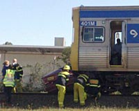
If the GPS appears to
be telling you to turn left at the rail line, don't
automatically accept its advice!
As amazingly accurate as GPS receivers can be, they
still can make mistakes.
Part 1 of a 3 part introduction to
GPS, as part of our broader series on GPS - see links
to additional articles in the series on the right. |
GPS technology is truly amazing
and close to magic, but there are still limitations on what it does and
how it does it.
It is only when you appreciate
the limitations as well as the capabilities of GPS that you'll
be able to get reliable best use from your unit.
There are too many stories of
drivers who have blindly trusted the information on their GPS
screen, ignoring the conflicting real world information on the
road. Never do this. Use common sense and understand
that if there is any doubt, what you see outside the car is of
course more correct than what the GPS is telling you!
Your First GPS?
For many people, their first
introduction to GPS is finding a unit installed in a rental car.
Or maybe they receive one as a gift.
The anticipation and
expectations of this marvelous magical new technology are
probably very high. But, as amazing as it is, it is not
perfectly flawless in all ways, at all times.
The information in this
three part article will help you better appreciate what, why,
and how your GPS can and can't do certain things.
How a GPS Unit Knows Where You
Are
It is amazing, really.
You turn on a unit that is about the size of a couple of decks
of cards, and it tells you exactly where you are. How does
it know this?
Those of you who remember
your high school geometry and trigonometry can 'fill in the
gaps' of the following explanation. In simple terms, the
GPS unit measures the distance between itself and a number of
satellites in the sky, and then, based on this information, can
calculate where on the planet it is.
That's the simple version.
But it helps you to understand a bit more than this, so you can
anticipate and understand when the GPS unit can not work out
where it is, or when it can't make this calculation as
accurately as in theory it could. These errors are not the
'fault' of the unit, but are often inevitable results of the
underlying math in its calculations.
How many satellites must a GPS
see?
A GPS needs to be able to
measure its distance to at least three different satellites in
order to calculate a two dimensional fix of its position (ie
latitude and longitude).
Not only does it need to be
locked on to at least three satellites, but they need to be in
different parts of the sky. The more widely spread out the
satellites are, the more accurate the calculation can be.
If the GPS can receive data
from a fourth satellite, it can then start to make a three
dimensional fix of its position (ie, latitude, longitude, and
altitude). It helps if one of the satellites is more or
less directly overhead, and, of course, if all four of the
satellites are reasonably equally spread around the sky.
Altitude calculations are
much less accurate than the latitude/longitude calculations.
Adding extra satellites - 5, 6, 7, even 8 or more - to the
number the GPS receiver is locked on to and using for reference
points will improve the accuracy of its calculation.
But as important as the
number of satellites is the location of them. Ten
satellites all bunched up in the same far corner of the sky
might result in the unit being unable to make any location
calculation at all, whereas just three or four, evenly spread,
might give a very good calculation.
It can sometimes be
interesting and helpful to look at your unit's satellite
receiving map (if it has such a feature). This feature (on
most Garmin units) shows a map of the sky and then the location
of the satellites in the sky, and highlights the ones which the
unit is locked onto and receiving good signals from. You
can quickly see at a glance if the unit is likely to be
receiving good reliable data or not from where the satellites
are.
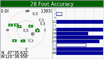
Here is an example of the
satellite screen display on a Garmin GPS. On the left is a
representation of the sky - the outer ring is the horizon, the
inner ring is a 45° angle from the horizon,
and the center is directly overhead. The right hand side
shows the strength and quality of signal for the satellites
being received. You can see the unit is locked on to seven
satellites, with two more that it is getting partial data but
not yet locked on to, and various other satellites that it
'knows' are out there but which it can't get any signal from
(due to obstructions).
The
computed 28' accuracy is, as always, an overly optimistic
number, but it gives you a relative feeling for the quality of
the fix - obviously 28' accuracy is better than 100' accuracy,
but not as good as 10' accuracy.
Looking
at where the satellites are in the sky, you'll see that there is
a reasonable amount of triangulation - there are satellites to
the left, right, and behind, with good angles between them,
making it easy to get a fairly good fix, as is suggested by the
28' accuracy.
Satellite number 48 is a WAAS satellite.
How many satellites can a GPS
see?
The GPS satellites move in
what can be considered semi-random patterns; sometimes there is
a bunch of them in one part of the sky and not many in other
parts of the sky, and sometimes they are evenly spread out.
Although there are typically
8 - 12 satellites in the complete 180°hemisphere
view of the sky above you, your GPS seldom has an unobstructed
view of all of these. A GPS basically needs a line of
sight view to the satellites - the very weak radio signals from
the satellites can't punch through much in the way of
obstructions, and so as a reasonable rule of thumb, if there is
any blockage between the receiver and the sky, satellites behind
that blockage will not be able to be seen and their signals
received.
If your receiver is mounted
in your car, you've immediately got the car roof obscuring much
of its view of the sky (mount the unit as far forward on the
dash as possible so as to reduce this obstruction) and even the
presence of yourself and other people in the car will block some
of the sky, too.
If there are hills or
buildings, these will limit the amount of the sky visible, too.
Go through a tunnel or drive into a covered parking lot and
you'll lose just about every satellite. Even things like a
dense tree cover can block the signals, which sometimes can't
even make their way through the tree leaves.
So while you start off with,
in theory, the ability to get signals from up to 12 or so
satellites, the inevitable nature of obstructions massively
reduces the amount of visible sky and satellites.
Your GPS receiver always
works best when it is receiving multiple signals, and from well
spread out satellites.
The Delay When You First Turn a
GPS On
When you first turn your GPS
on, it needs to 'tune in' to the satellites in the sky, and to
do this, it needs to know 'where to look' for the satellites.
(The phrases in quotes represent major over-simplifications of
what is actually happening.)
If the unit was turned off
just a short while ago, and then turned on again in the same
place it was turned off, the unit 'remembers' where the
satellites where, and assumes that it is still in the same place
it was a short while ago too, so it knows where to 'look' for
the satellites and can quickly 'find' them again and lock onto
their signals.
This is variously referred
to as a warm or hot start, depending on exactly how up to date
the unit's information is.
But if the unit has been
turned off for a day or two, and/or if it has been moved while
it was switched off (for example, you take your unit out of your
car, fly with it somewhere, and then turn it on in the rental
car at the destination), not only has it forgotten where the
satellites are, but it also doesn't know where it is, and so it
has to start afresh from the very beginning of looking
everywhere for any satellites and computing its position
potentially anywhere on earth.
This is referred to as a
cold start.
More detailed explanation
In order to lock onto
satellites and use their location signals, the receiver needs to
do two things. Firstly, it needs to know about where in
the sky each satellite is likely to be. This information,
which is called the 'almanac' is transmitted by all satellites
once every 12.5 minutes, and gives a list of all currently
working satellites and their paths/positions over the next up to
six months.
Once the GPS has found any
satellite, it downloads the almanac information, and then knows
approximately where to look for satellites (assuming the GPS
also knows more or less where itself is located).
After it finds each
satellite, it then needs to download exact detailed information
from each satellite about exactly where the satellite is.
This information, called the 'ephemeris' information, is
transmitted by each satellite every 30 seconds, and is good for
up to four hours, so needs to be continually updated.
If the GPS unit already
accurately knows where it is, and has current ephemeris data,
when it is switched on it only needs to do a hot start, which
can be very quick. If it knows where it is (to within
about 65 miles) and has up to date almanac information but needs
ephemeris information, it does a 'warm start' which takes a bit
longer. And if it has out of date almanac information, or
has moved more than 65 miles, it will need to do a cold start,
which is the longest/slowest process.
Normally, with a GPS in our
car, and with us turning the GPS on (probably automatically when
the ignition goes on) every time we drive the car, and with
driving the car every day or two, the GPS unit will be doing
warm or hot starts.
How long this all takes
The time it takes from
turning a unit on until when it has completed calculating its position is referred to as the unit's 'TTFF'
(Time To
First Fix) or acquisition time.
In the 'bad old days' (ie
about ten years ago) units with single channel receivers could
take half an hour or more to calculate their position from a
cold start, and could take five minutes to calculate their
position from a hot start. Nowadays, units with
multi-channel receivers (ie, they can listen to many satellites
simultaneously rather than just one at a time) can do a hot
start in 5 - 30 seconds, a warm start in about a minute, and a cold start in
no more than 15 minutes (assuming the unit can clearly see a
sufficient number of satellites).
If you're getting into a
rental car, the GPS unit in the rental car may not have been
used for some time, and will need either a warm or cold start.
There's one additional
complicating factor in the time it takes for a GPS to acquire
its first satellite fix. If you start driving around, you
can lengthen the time this takes considerably, because as you
drive, various satellites will come into view and go out of view
again, so as some satellites disappear, you 'lose' the time the
unit has take to tune those in, and the unit has to restart the
process again to get more satellites, and so on.
If you're collecting your
rental car from an open lot with a clear view of the sky, the
very first thing you should do is turn on the GPS, even before
you load your bags in the car. And if you've flown
somewhere with your own GPS, as soon as you're at the rental car
lot or somewhere else, stopped, with a clear view of the sky,
turn the unit on and have it update itself on where it is and
where the satellites are.
If your rental car is in a
parking garage, then the GPS receiver will probably not be able
to find any satellites until you drive out of the garage and
onto the street.
Losing and regaining satellite
signals
Say you're driving along and
go underneath an overpass on the freeway, and briefly lose
satellite signals. Or perhaps you turn a corner and a
building that had been blocking your view in one direction now
shifts its position as you turn and blocks other parts of the
sky briefly, obscuring some satellites that you'd formerly been
receiving.
In such cases, you'll of
course lose some or all of the satellite signals you'd been
receiving. If you only lose a few satellite signals, the
GPS might still be receiving signals from enough satellites as
to still know where you are. And, of course, with moving
obstructions, while they are blocking some satellites they might
be unblocking other satellites at the same time.
In effect, as satellites
shift in and out of view, the receiver is continually doing 'hot
starts' to regain the signals from the temporarily obscured
satellites. This means you might not even notice the
occasional loss of signal, or, if you do, it should quickly be
restored as the temporary obstruction disappears.
Dead Reckoning
This sounds like the title
of a mystery or western novel. But it refers to the
ability of a GPS to use other methods of calculating where you
are and where you are going.
Dead reckoning can be useful
if the GPS briefly loses satellite signals, or gets 'confused'
(for example, with bad signals and lots of streets to choose
from when driving in a high rise concrete jungle downtown).
Dead reckoning, in its most
sophisticated form, adds a compass sensor to the GPS to tell the
GPS, on the rare occasions when it doesn't already know this,
what direction you are heading in, and then adds extra sensors
from the vehicle to tell the GPS about the vehicle's speed and
perhaps also supplements the compass sensor with turning
information from the vehicle too.
In a simpler, self-contained
form, dead reckoning might comprise a compass sensor and an
accelerometer within the GPS. This enables it to know what
direction you're heading, and to sense any increase or decrease
in speed (and turns) through the accelerometer.
In its simplest form,
if/when the GPS loses satellite signal, it simply assumes that
you are continuing in the direction and at the speed you'd been
traveling at immediately prior to losing the signal, and it
continues to plot you along that path for a while before it
decides it can no longer continue with this assumption and gives
up.
Dead reckoning, if used
intelligently, can make a GPS enormously more helpful.
I've watched regular GPS units get very confused, particularly
in downtown areas, with the location pointer seemingly randomly
jumping from street to street and back again. But my
Landrover GPS, with dead reckoning, never does that, because the
GPS supplements its location calculation from the satellites
with vehicle information and so it 'knows' that there's no way
the vehicle is magically jumping from street to street and back
again. Instead, if it has a temporary conflict between its
calculated position and what the dead reckoning tells it is
happening, it makes a (usually sensible and correct) decision
with this extra information.
It can also be helpful when
driving along a freeway that has underpasses and overpasses in a
spaghetti type interchange, and you are being instructed to take
a series of one of many different sets of exit combinations, and
just when you most need to be walked through your turns, the GPS
suddenly freezes and flashes a 'bad satellite coverage' message
at you.
If a unit does offer dead
reckoning, it is important to appreciate that the accuracy of
its dead reckoning is vastly less than that of its GPS receiver,
and, importantly, the dead reckoning accuracy gets worse and
worse over time, and if it isn't updated by GPS information
fairly quickly, it will become unhelpful and may become
misleading.
A clever enhancement to dead
reckoning is an extension of the 'snap to road' concept.
If the dead reckoning calculates you to be 100 yds from an
intersection, and then suddenly senses you turning left, it may
be clever enough to tell itself 'hmmm, I guess I was wrong, we
are already at the corner' and update its location calculation
based on the assumption you turned on to the road rather than
into a driveway it knows nothing about. This type of
self-correcting can extend the period of time for which dead
reckoning remains accurate and useful.
If you have a chance to
choose a unit with dead reckoning capabilities, you should do
so, even if it costs more than a unit without this capability.
It significantly improves the value, accuracy and reliability of
the information your GPS will provide you.
Read more in the GPS
articles series
See the links at the
top right of the page to visit other articles
in our extensive GPS series.
This particular article is
part 1 of a three part
article introducing you to GPS receivers, and what they can
and can't do. Please
also visit
1.
Beginner's Guide Part 1 - How the GPS
Knows Where You Are
2. Beginner's Guide Part 2
- Maps, Routing and ETAs
3. Beginner's Guide Part 3
- Errors, Inaccuracies, POIs, Speed
Related Articles, etc
|
If so, please donate to keep the website free and fund the addition of more articles like this. Any help is most appreciated - simply click below to securely send a contribution through a credit card and Paypal.
|
Originally published
6 Jun 2008, last update
21 Jul 2020
You may freely reproduce or distribute this article for noncommercial purposes as long as you give credit to me as original writer.
|