|
A Beginner's Guide to Using GPS Part 2
All about Maps, Routing, and ETAs
|
|
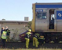
If the GPS appears to
be telling you to turn left at the rail line, don't
automatically accept its advice!
As amazingly accurate as GPS receivers can be, they
still can make mistakes.
Part 2 of a 3 part introduction to
GPS, as part of our broader series on GPS - see links
to additional articles in the series on the right. |
GPS technology is truly amazing
and close to magic, but there are still limitations on what it does and
how it does it.
It is only when you appreciate
the limitations as well as the capabilities of GPS that you'll
be able to get reliable best use from your unit.
There are too many stories of
drivers who have blindly trusted the information on their GPS
screen, ignoring the conflicting real world information on the
road. Never do this. Use common sense and understand
that if there is any doubt, what you see outside the car is of
course more correct than what the GPS is telling you!
Routing Logic
When you ask the GPS unit to
navigate you to a specific destination, the unit goes through an
amazing number of 'what-if' type calculations to calculate what
it believes to be the 'best' route for you to follow.
Now, you know that any time
you are choosing to drive anywhere, you have choices of route,
choices such as do you take the surface streets or the freeway?
Do you take the main roads or the back roads? And so on.
Many times you're never quite sure which is the best, and you
might have many different ways to get some where. You make
your ultimate decision based on all sorts of factors - maybe
even the weather and which route you want to have a break from
driving all the time.
How does a GPS handle these
choices? It makes a decision based on a number of
assumptions. Some of these assumptions are built in to the
unit, and some you can program in yourself.
The types of assumptions
that it considers might include :
-
How fast can you drive on
different types of roads (so as to work out the fastest
route)
-
Do you prefer to drive on
freeways or surface streets
-
Do you want to drive on or
avoid driving on toll roads
-
What type of vehicle are you
driving (if you are on a motorcycle you'll be happy on
different routes than if you're in a big truck)
-
Would you rather go a longer
route that takes less time to drive, or a shorter route that
takes more time to drive
-
Which route is least
congested with traffic (some units get information about
traffic on some roads, other units don't)
Most units allow you to
choose the answer to some of these questions yourself, and a few units allow
you to answer all the questions.
When the unit has decided on
a route for you, some units will then present you with some
route choices, while others just show you the one best route.
It is important to
understand that the route you are presented with is not
necessarily truly the best route, because it reflects the
assumptions made by the unit, and is also based on what the unit
thinks it knows about different roads and traffic conditions,
etc, and what the unit assumes your preferences might be.
Sometimes the unit will come
up with very strange routes, and - even harder to understand -
sometimes the unit will give different routes to the same place
on different occasions. That is a bit like asking a
calculator to add 2 + 2, and sometimes getting an answer other
than 4!
For example, my Garmin 680 sometimes
tries to save me a few feet of traveling distance by having me
take a freeway off ramp, then immediately go back onto the
freeway on the matching onramp. This is a crazy suggestion
- usually there is a traffic light or stop sign at the end of
the offramp, making it much slower to go off and on the freeway.
What to do if you know there
is a better route
If you know a better route
than the one suggested, just follow the route you know.
Almost every unit these days will automatically recalculate its
route based on where you are, and when you drive off its route,
it will be forced to recalculate based on your current direction
of travel, and sooner or later, it will probably end up
selecting the same route you are wanting to use.
Sometimes my Garmin gets
really fixated on a specific route, and keeps trying to get me
to return to it, even though it ends up being a longer distance
and longer traveling time. Then, when it finally gives up
and accepts the route I'm clearly proceeding on, suddenly the
travel time and distance massively reduces. Even more
strangely, the point at which it gives up sometimes varies from
day to day.
I've no idea why the unit is
so 'temperamental', but it is, and after using it extensively,
I've started to get a feel for how it 'thinks'. When you
first get a new unit, that is not possible, and the key concept
here is just to realize that if you think you know a better
route than the one being suggested, you very well might be
correct.
Illogical preferences
An extreme example of this
is in my Landrover. Although, in theory, the Landrover is
the ultimate 'go anywhere' vehicle, the built-in GPS, which
Landrover is very proud of, refuses to route me on minor roads,
even when it shows the minor roads on the map.
It will detour me many miles
on major roads rather than take a shortcut on a perfectly
normal, two-lane, fully-sealed minor road, and if I do end up
driving on minor roads, it refuses to navigate at all until I go
back onto major roads.
My Garmin unit is perfectly
happy on minor roads, but the Landrover GPS is not.
This is a good example of an
illogical routing preference, and there is no way I can override
it.
A different example is when
I'm driving between two points that are almost exactly opposite
each other on a circle. To get from one place
(Leavenworth, WA) to the other place (Redmond, WA) I can either
go clockwise (130 miles with over half on freeways) or
counter-clockwise (110 miles with no freeway driving).
The 130 mile route is
faster, easier, and more predictable; the 110 mile route is more
of a hassle, slower, and if you get stuck behind a slow moving
vehicle or two, can be very slow indeed. The Landrover GPS
correctly defaults to the 130 mile route but offers the 110 mile
route as an option, the Garmin GPS really likes the 110 mile
route and never offers the 130 mile route. I have to drive
about 10 miles in the opposite direction to the way it insists I
go before it relents and allows me to proceed in that direction.
Estimated Time of Arrival
Many units will show an
estimated time of arrival, and some units, if they offer you
different route choices, will show you how long they expect each
route choice will take to drive.
Units will often give you a
choice of showing your ETA either as the time at which you will
arrive, or the number of minutes driving time remaining.
Some people prefer to see their ETA expressed one way, others
prefer the other way. There's no right or best way to
display this data.
This information is based on
information the unit has about the road types you'll be driving
on, and the typical average speeds you'll achieve on these road
types. Some units will also adapt their ETA based on the
actual speeds you are driving at - for example, if it had
assumed the average freeway speed would be 65mph and you have
been averaging 75mph, it will change its assumption for your
present route to reflect that experience.
On the other hand, bad units
don't differentiate between different types of roads at all, and
just estimate your arrival time based on miles to go and your
recent average speed - a totally useless calculation. If,
perhaps, you have 10 miles of surface streets (average speed 20
mph) and then 40 miles of freeway (average speed 60 mph) the
correct ETA would be 70 minutes, but if the unit took the 20mph
average from your first surface street driving, it would
estimate a 150 minute driving time - more than twice as long as
it will actually take you. Alas, some units are this
unhelpful.
ETA information is
notoriously unreliable and should be considered only as a very
approximate guide. I've generally found that units are
typically very optimistic about surface street speeds, and more
realistic about highway speeds. That is, if the unit says
it will take 20 minutes to drive a route on surface streets, it
is likely to take at least 20 minutes and maybe 30 or even 40
minutes. But if it says it will take an hour of freeway
driving to go somewhere, it is usually more accurate about that.
After a while, you'll get a
feeling for how the ETA calculation is done in your unit and
will know whether to rely on it or not, and what type of
adjustment factors to apply to the unit. But until then,
be aware that this is one of the most error prone parts of your
GPS.
One last cautionary note -
if your ETA shows you are 'falling behind schedule' don't feel
that means you are driving too slow and need to speed up.
As always, drive at a safe comfortable speed, no matter what
happens to your ETA.
The Map used by the GPS Unit
The saying about computers -
'garbage in, garbage out' is even more true when it comes to GPS
units. A GPS unit will only direct you to your destination
via roads that it knows about.
While modern day map data is
vastly improved over that of even just five years ago, it still
remains unavoidably imperfect. You will typically find
several different types of potential problems in any given set
of map data - some roads may be missing entirely, other roads
may be present in the map data but no longer in the real world,
and some roads may be in the wrong place or with wrong
connecting data.
In any given twelve months,
there are literally hundreds of thousands of changes to the US
map database. Most of these of course won't concern you,
and changes in your local area you'll automatically adjust for,
but you need to realize that the data in your GPS starts off as
being imperfect to start with, and then proceeds to get worse
and more out of date with every passing day.
Unfortunately, the map data
in your GPS doesn't automatically update itself (this is under
development but not yet commonly available). The only way
to get more up to date map information is to buy a newer copy of
the data - this typically costs about $100 or so, and may be
published about once a year. Remember also that when you
purchased your unit to start with, the map data you received
with it was already of an uncertain vintage.
Any time you're traveling
somewhere that is experiencing rapid growth and development (eg
Florida) you might want to consider updating your map data
before you travel, so as to be sure you've the latest
information in all the new roads, freeways, exits on existing
freeways, etc, that is being added. A GPS becomes totally
useless when it doesn't know about the place you're trying to go
to, or the road you're driving along!
The important thing to keep
in mind is that while the map in your GPS seems extremely
detailed and exact, it may not be perfectly correct and may not
be perfectly complete. Trust the real world around you and
what you see on the street more than what you see on your
screen.
There have been some classic
situations where people have blindly followed the directions on
their GPS screen, causing them to drive down roads that have
been clearly marked as closed, or even to turn onto railroad
tracks instead of a road. Don't end up as another such
joke/story!
An important tool - an old
fashioned map
If you're in an unfamiliar
part of the country or world, you probably should travel with a
regular map as well as your GPS.
Hopefully you'll never need
to refer to the paper map, but there may be times when it is
very helpful. Sometimes I've found it a real life saver,
particularly in situations where the GPS map is wrong - most
commonly caused by a road closure on the route it is suggesting.
Sometimes the 'detour'
feature on the GPS will work to route you around a closed road,
but sometimes it won't, and in such cases, a regular paper map
is very much quicker and more convenient to help you see the
broader picture of all the roads in an area and how to route
yourself around the obstruction.
Because GPS units have small
screens, they can't display as much information as a regular map
can. Here's a startling comparison - a large 4.3" GPS
screen has 130,560 pixels of information on it. By
comparison, a typical Rand McNally type map on one page of a map
book has about 12.5 million pixels of information on it - it can
display up to 100 times as much information. Of course, it
doesn't show you 100 times more information, but it does show
you a huge amount more than the GPS can, and you don't have to
fuss about with zooming in and out and being frustrated by, as
you zoom, having roads appear and disappear on the GPS screen.
A map can also help you
understand the good sense (or lack of sense) in the route the
GPS is suggesting, and can help you understand what other
alternatives you might prefer.
So, as counter-intuitive as
it seems, it is prudent to supplement your GPS with a regular
map, especially if you're in an unfamiliar region.
Read more in the GPS
articles series
See the links at the
top right of the page to visit other articles
in our extensive GPS series.
This particular article is
part 2 of a three part
article introducing you to GPS receivers, and what they can
and can't do. Please
also visit
1.
Beginner's Guide Part 1 -
How the GPS Knows Where You Are
2. Beginner's Guide Part 2 -
Maps, Routing and ETAs
3. Beginner's Guide Part 3
- Errors, Inaccuracies, POIs, Speed
Related Articles, etc
|
If so, please donate to keep the website free and fund the addition of more articles like this. Any help is most appreciated - simply click below to securely send a contribution through a credit card and Paypal.
|
Originally published
6 Jun 2008, last update
21 Jul 2020
You may freely reproduce or distribute this article for noncommercial purposes as long as you give credit to me as original writer.
|