|
An Introduction to GPS Navigation
You'll never be lost with a GPS
Navigation unit
|
|
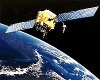
This GPS (Block IIF)
satellite, along with 23 others, all located 11,000 miles
above the earth enables you to know exactly
where you are.
Amazing technology made simple and easy with a modern GPS
receiver.
This is the start
of a new series on GPS - additional articles to be
published in coming weeks. |
GPS receivers are one of the
modern miracles of our age. They receive signals from
satellites 11,000 and more miles away and from that information
instantly calculate where you are to an incredible accuracy of
sometimes within ten feet or less.
Small sized, light weight, easy
to operate, and increasingly affordable, they are becoming more
commonly included in new vehicles, and a wide range of
standalone units makes it easy for anyone to add a GPS unit to
their vehicle.
No More Getting Lost, Ever
A typical business trip for
me often involves flying to an unfamiliar city, arriving after
dark, and then struggling to drive an unfamiliar car to an
unknown location, with an inadequate rental car company supplied map and
ambiguous directions balanced on my knee.
Even if such an arrangement
doesn't lead to an accident, it surely can lead to much
frustration, missed turns, and getting hopelessly lost
(invariably in a bad part of town).
Or, when on vacation
overseas, the quaint old towns in Britain and Europe are very
difficult to navigate through. Winding roads, one way
streets, no left turns, combine with one's own errors at map
reading to make traveling by car frustrating and unpleasant.
In both these cases, and any
other time you're needing to know where you are and/or where to
go, a modern GPS Navigation Unit can completely solve the
problem. Its 'moving map' display shows you exactly where
you are on the map, and it will highlight the turns you need to
make to get you where you need to go. And if you should
still miss a turn, that's not a problem either. The unit
will quickly recalculate the best revised way to get you where
you are going.
GPS units have transformed
the ease and ability with which we all can travel. If you
don't already have one, you should get one.
What a GPS Receiver Can Do For
You
A GPS receiver calculates
your location (and perhaps also your altitude) based on the time
it takes for radio signals to reach the receiver from different
transmitters.
It can also calculate your
speed and direction based on changes in your location, and many
GPS units add 'trip computer' functions such as telling you the
average, maximum and instantaneous speed, and the distance
you've traveled. The GPS information is usually more
accurate than your car's speedometer and odometer, so this is a
convenient way of checking them to see if they're accurate.
When you've set a
destination, the GPS can then provide an estimated time of
arrival and distance remaining to travel. Better GPS's
make an uncannily accurate prediction of your arrival time
because they 'know' how much of the journey is on freeways, how
much on regular highways, and how much on congested city
streets, and the sort of speeds you can travel at on these
different types of road.
As part of their map
information, a GPS will typically also be able to tell you where
nearby restaurants, hotels, gas stations, and other 'points of
interest' are.
Realtime location based
information
More sophisticated GPS units
link up with real time information about things like freeway
traffic conditions and road works to help you avoid congested
areas, and can even provide local weather forecasts, and
information on nearby cinemas and what they are currently
screening.
A wonderful feature on some
GPS units is telling you not just where nearby gas stations are
but also their current prices for gas. This can save you
both time and money each time you need to fill up, but note that
not all gas stations report their pricing to the MSN Direct
service so the information is incomplete.
 How GPS Works How GPS Works
A standard GPS unit receives
signals from a 'constellation' of satellites in low earth orbit.
More advanced GPS units supplement these signals with extra
signals from ground based transmitters, giving them more
accuracy.
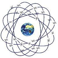
In theory there are a
minimum of 21 satellites and three working spares in six
different orbit paths, all inclined 55°
from the equator, which is enough to ensure there are
always at least four visible from anywhere in the world.
In practice there are usually more than 24 satellites aloft and
operational (eg 27 at present), and it is common to have many
more than four satellites visible at any given time and place.
The satellites weigh just
under a ton each, are 10,900 miles above the earth, and circle
the earth once every 11 hrs 58 minutes, meaning they're in a
slightly different orbit every time.
Satellites have a typical
life span of 7.5 years before replacement, so every year, on
average, 3.25 satellites need to be replaced.
GPS satellites broadcast a
signal on two frequencies, 1575.42 MHz (L1) and 1227.6 MHz (L2).
Your satellite receiver uses the information in these signals to
work out the distance to each satellite, and then solves a
simple trigonometric equation to calculate its position on the
earth based on its distance from the various satellites it
receives signals from.
The accuracy of a GPS unit
is truly astonishing when you consider how it is calculated.
With accuracy of approximately 40', this means the unit can
discriminate delays in receiving a radio signal as small as a
twenty five millionth of a second (this is the time it takes a
radio wave to travel 40', and based on information from
satellites in orbit 10,900 miles above the earth's surface.
How Accurate is GPS
The accuracy of a GPS
receiver is based on a number of factors. Most of these
factors can't be controlled - for example, random variations in
the ionosphere which slightly impact on the speed of radio
signal propagation (which is estimated to be the largest single
variable, providing a potential error of about 13.5'). A
couple of errors can be optimized but not eliminated (getting as
accurate a clock as possible, and optimizing the receiver
circuitry) but these factors are already as close to perfect as
possible (representing, between them, about an 8.5' error).
The theoretical error radius
between where the GPS calculates you as being and where you
actually are is generally considered to be in the realm of 40'
to 50', assuming no additional aggravating factors.
Prior to May 2000, the
accuracy of civilian GPS units was deliberately downgraded (by
sending a less exact signal, termed SA - selective availability) so that accuracy was limited to
about +/- 100', but since then, GPS accuracy is no longer
downgraded and most receivers can theoretically establish
accuracy to within about 40' - 50'.
Some GPS units will display
a constantly changing theoretical accuracy of their information,
so you know how reliable the information is. This
information isn't exact, but if the GPS unit is showing a
theoretical 30' accuracy, you know it is giving you a better
answer than if it is showing a theoretical 300' accuracy.
The actual GPS accuracy is
determined by several factors :
How many satellites the GPS
receiver 'sees' in the sky
There are at least 24 GPS
satellites circling the earth (the number varies depending on
when satellites fail and how many spares are already in orbit
waiting to be deployed).
These are not
'geosynchronous' satellites; in other words, rather than staying
fixed above the earth in a certain point, like a tv satellite,
they are all the time moving relative to our positions on the
planet. Sometimes there will be satellites almost directly
overhead, and other satellites may be just above the horizon in
any direction, or anywhere else in the sky.
The number of satellites
your GPS receiver can 'see' (and receive signals from) is
regularly changing, depending on where the current 'cloud' of
satellites are located relative to you, and what obstructions
there are between the GPS receiver's antenna and the satellites
(signals are strictly line of site only). In theory, and
assuming no massive obstructions to the line of site path, you
can always receive signals from at least four satellites, and
often will have eight satellites, and sometimes even more.
A GPS needs to receive
signals from at least three satellites before it can calculate
your position in two dimensions, and at least four satellites
before it can calculate your position in three dimensions (ie
including your height/altitude as well as your latitude and
longitude).
Where the satellites are
located
Because of the trigonometric
calculations your receiver must do to work out its location from
the information it receives from the satellites, it helps if the
satellites are evenly spread around the sky.
If the satellites were all
in a straight line, the calculation would be much less reliable
than if they were spread around, with some satellites in front,
some to the left, some to the right, and some behind you.
If the GPS has D-GPS or WAAS
capability
These two extensions to
basic GPS functionality are explained below. For now,
suffice it to say that if your GPS receiver has - and is using -
either of these two enhancements, its accuracy will be
appreciably better than if it is not using either.
If the GPS also uses dead
reckoning
Some GPS units, especially
those pre-installed in cars, supplement their GPS
calculations with dead reckoning for times when they don't have
sufficient reliable satellite information. If the GPS
knows how fast your car is driving, and in what direction (and
it can obtain this information from the speedometer and the
position of your steering wheel) it can make reasonably accurate
estimates for where the car is and where it is going to,
especially when it adds the assumption that you're driving on
the roads rather than going offroad.
It is also possible for a
GPS to calculate some of this data itself by use of internal
accelerometers that can tell it whether you're speeding up or
slowing down, and if you're turning or going straight ahead.
This dead reckoning quickly
becomes less and less accurate, but usually is only needed for
short stretches of time - for example, if you're going through a
tunnel, or if you're in a city 'canyon' with tall buildings all
around you blocking your view to the satellites.
If the GPS has a 'snap to
roads' feature
It is possible, due either
to errors in the map data about where the road is exactly
located, or due to limitations in the GPS accuracy (or due to
both factors together) that the GPS may end up thinking that you
are driving not on the road but perhaps 100' to one side of the
road - through buildings or whatever.
Because of this, many GPSs
offer a 'snap to roads' feature to tell the GPS that anytime
it calculates that your car is traveling close to and parallel
to a road, it should assume you are actually on the road itself.
This can be both a benefit and a hindrance.
It is a benefit because it
makes it easier for you to see exactly where you are. But
it can also be a hindrance, because sometimes you end up
tricking the GPS into making a wrong assumption. For
example, if you are in a car park close to the road, and then
drive through the carpark, parallel to the road, the GPS will likely assume you're on
the road itself. And then when you drive out of the
carpark to the street, the GPS might then move you over to the
next block, and for the next considerable time might be showing
you driving along the wrong block (this happens to me on
occasion).
How is Accuracy Measured
There's an important thing
to understand when talking about accuracy. A full
statement of the accuracy of a unit comprises two pieces of
information - the distance accuracy being claimed, and the
percent of time the unit is accurate to within that limit.
But most GPS accuracy claims
only tell you the first part of the statement - the distance
accuracy being claimed, and don't tell you what percent of time
the unit is expected to be accurate within that limit.
Because accuracy errors are
semi-random, sometimes the error can be zero, and so a person
could say 'this unit is accurate to within six inches' and be
correct some of the time - the key factor in that statement is
the (usually unstated) issue of how much of the time the
accuracy level is achieved.
The higher the percent of
time the accuracy standard is being achieved, the broader the
accuracy tolerance that needs to be given. For example, a
device may indeed be accurate to within 6", but only 1% of the
time. It might be accurate to within 3' 25% of the time,
to within 6' 50% of the time, and to within 10' 75% of the time,
to 20' 95% of the time, and nearly always to within less than 100'.
So the accuracy claim can
vary widely, depending on what percentage of the time it must be
met. Scientists usually choose to adopt a 95% or higher
rating (they often call this a 'confidence level'), but
marketeers may feel that 51% is enough for a 'better than half
the time' concept to be established.
Basically, we suggest you
don't consider accuracy claims as being relevant in your choice
of GPS units, because most units have similar accuracy - indeed
the vast majority of units use exactly the same chips to decode
and calculate the unit's position.
Two Enhancements to Standard
GPS Accuracy
There are now two different
types of enhancements that can further improve the accuracy of a
GPS unit, sometimes giving you an accuracy of as little as 5'
between your actual position and your computed position.
And if you think that is
amazing (which of course it is), military (and commercial
surveying) applications offer
even greater accuracy.
DGPS
DGPS, short for Differential
GPS, adds a land based transmitter to the satellite based
transmitters. The land based transmitter is typically very
much closer to your receiver, and the signal has a shorter more
reliable path to travel to get to your receiver, allowing for
more accurate location calculations.
Accuracy is typically
improved to about 5' - 15', depending on how close you are to
the DGPS beacon.
The two disadvantages of
DGPS for most users are the need to have a second separate
receiving unit to get the DGPS signal, and the need to pay an
ongoing fee to be able to use the DGPS service.
WAAS
WAAS, short for Wide Area
Augmentation System, is a more recent enhancement and in many
respects can be considered a replacement for DGPS, and may offer
better accuracy too.
A network of fixed ground
stations continually monitor the GPS satellites in the sky, and
compare the calculated location given by the satellite data with
the actual location of the ground station. It then
calculates continually varying correction factors and
rebroadcasts those over extra satellites.
If you have a WAAS enhanced
GPS receiver, it will receive the normal satellite signals and
also the WAAS correction signals, and by applying the WAAS
correction factors to its calculation, can come up with a much
more accurate result - typically giving you accuracy of about
10' - 20' both in terms of location and altitude.
WAAS is free and requires no
additional receivers. Most of the modern middle and higher
end receivers have WAAS capabilities. A European
equivalent of WAAS is EGNOS (European Geostationary Navigation
Overlay Service).
Strangely enough, our
testing of WAAS equipped units (eg
Garmin Nuvi 680 and Garmin Nuvi
660) have shown very little difference in claimed accuracy
as to with WAAS enabled or disabled. We had both these two
units side by side and would alternate between having one unit
with WAAS on and the other with WAAS off, or both units with
WAAS on or off.
There was almost no
appreciable difference in claimed accuracy, with the 680 usually
showing slightly better accuracy than the 660, no matter which
unit had WAAS on or off.
It may be fair to say that
default regular GPS is so accurate these days that WAAS no
longer offers the significant improvement in accuracy that it
formerly did.
Altitude Accuracy
Due to how location is
calculated, GPS units are not as accurate when displaying
altitude as they are when displaying latitude and longitude, and
more satellites are required to get any type of result (a
minimum of four to calculate 3D positions compared to three
satellites for 2D positions).
Altitude accuracy can
generally be expected to be at least 50% worse than for the 2D
accuracy.
This accuracy is compounded
by the fact that the reference 'zero' level - sea level - isn't
constant around the planet. The earth isn't exactly
spherical, and has various bulges and hollows.
What this means is you may
sometimes be driving alongside the ocean and see your GPS
telling you you're at an improbable 250ft below sea level (or an
equally improbable 250 ft above sea level).
Mapping Accuracy
If your GPS
is suggesting that your car is driving off the road on its map
display, don't immediately blame your driving or the GPS.
It is equally likely that
the map data in the GPS isn't completely accurate, and maybe the
GPS is truly showing where your car is located in terms of
absolute latitude and longitude data, but the map data in the
unit thinks the road is somewhere other than where it truly is.
Map data also ages - new
roads and freeway exits are added, and information in 'Point of
Interest' databases (lists of restaurants, gas stations, tourist
attractions, etc) also changes quite rapidly as businesses are
opened, sold, or closed.
Almost all GPS receivers use
mapping data from one of only two different suppliers. The
better established supplier of mapping data is NavTeq, and the
newer supplier is Tele Atlas.
Until recently many people
believed the NavTeq data to be more reliable than the Tele Atlas
data, but it seems the gap has narrowed and there's little to
choose between them. More important than which supplier
provides the mapping data for your GPS are considerations about
how recently it was updated, and what the policies (and costs)
are for you to acquire ongoing updates into the future.
Summary
GPS receivers can be as
small as to fit into your shirt pocket, and priced for $200 or
less (we'll be reviewing a good $200 unit in a couple of weeks).
Their twin functions - of
showing you where you are, and helping you know how to get to
where you want to be - make them invaluable and essential any
time you're driving somewhere you're not 100% familiar with.
If you don't already have
one, use the information in the second part of this series about
how to choose a GPS unit (due to be published on 23 March) and
get one.
Read more in the GPS
articles series
Coming soon - see the links at the
top right of the page to visit other articles
in our GPS series.
Related Articles, etc
|
If so, please donate to keep the website free and fund the addition of more articles like this. Any help is most appreciated - simply click below to securely send a contribution through a credit card and Paypal.
|
Originally published
16 March 2007, last update
21 Jul 2020
You may freely reproduce or distribute this article for noncommercial purposes as long as you give credit to me as original writer.
|