A Buying
Guide to iPad and other Tablet Devices : Part 6
GPS, Mapping, Location Based Services,
and Game Controller capabilities
|
|
The larger screen of a
tablet device is well suited for a displaying variety of
navigational information, as well as traditional mapping
type applications.
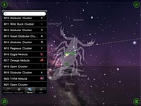
This screen shot shows
how you can point an iPad at the sky and it shows you the
names of the stars you are looking at.
|
The inviting large clear screen
on a tablet calls out to be used for mapping type applications,
and if the tablet has a GPS unit and other motion/location
sensors, it can become an extremely sophisticated navigation
device, and not only for traveling on land, but on the water,
through the air, and even looking up at the heavens above too.
But there are some potential
traps when choosing GPS type applications in terms of their
'cost' to you in data downloading and whether or not they
require a 3G data service too.
This part of our buyer's guide
series considers GPS and LBS issues, and their related extension
of using tablets as interactive game controllers too.
TLAs - GPS & LBS
Okay, I'll translate.
I was referring to a couple of 'Three Letter Acronyms' that are
becoming increasingly common and arguably essential on tablet
and phone devices - GPS, which probably requires no further
explanation, and LBS, which stands for 'Location Based
Services', most of which require GPS as a base from which to
extend.
One of the potentially
appealing uses of a tablet is to use its lovely large screen as
an electronic map and GPS unit. Okay, you're probably not
going to want to mount an iPad on your car windshield, and for
sure, if you did, you'll want to take it off and hide it
whenever you're leaving your car unattended, but if you're
traveling with a companion, they could become your navigator
with the iPad or other tablet device in their lap - assuming the
device has a GPS unit and some type of mapping software.
Where is the map data stored
There is one important thing
to appreciate with GPS and mapping software apps. Some of
these will use a map that has been downloaded to the device in
advance, and some of these will be interactively downloading the
map data for exactly where you are, as variously needed, while
you are traveling about the place.
A single map file for the US
can require up to 2GB of data storage. This isn't a problem with a
64GB iPad, but if you have a different type of tablet that only
has 2GB of built in storage (some of which will invariably and
unavoidably be needed for assorted other essential applications
and their related data) plus one Micro-SD card slot, you'll need to use the Micro-SD slot for the map data and that
will then prevent this slot from being used for other things at the
same time.
In such cases, the idea of
just interactively downloading data as you travel becomes more
appealing. In theory this also means you're always
accessing the very latest and most up-to-date map data, but
we're not entirely sure that the map data publishers have a
continual realtime series of mapping updates, so this may or may
not be a relevant extra plus feature.
In any event, downloading
map data as you need it embodies some assumptions and potential
problems. It presupposes you have a 3G data plan from a
phone company, that you're not downloading too much data as to
incur appreciable extra data charges, and that you're always in
areas with good fast 3G data coverage.
This becomes even more
relevant if you are traveling internationally, where you can
expect to pay exorbitant rates for 3G data service (sometimes
even $10 - $15 per MB).
For these reasons, we
generally prefer products (such as CoPilot Live) which use a
local map database already preloaded into the tablets storage, but of course that then requires a tablet
device with plenty of built in storage capacity.
In addition to GPS, a
digital compass and accelerometers can be used by the device for
'dead reckoning' in areas of poor GPS signal, although not many
of the GPS programs support dead reckoning. If you can
find one that does, we'd strongly recommend you get it however,
because driving around the central downtown areas can often be
problematic with poor GPS signals and the mapping program
sometimes jumping from one block to the next and back again,
being unable to decide exactly which block you're on.
Accelerometers and
gyroscopes can be
used for various other functions too, especially to do with
interactive gaming, where you can use the entire tablet as a
game controller - for example, as a steering wheel. The
accelerometers and possibly gyroscope can sense you turning the
device in your hand, and translate that to the effect as if
you'd been turning a steering wheel.
Part of the capabilities
given by an accelerometer is the ability to sense which way the
screen is positioned and to automatically adjust its orientation
to match how it is positioned. This is convenient most of
the time, but sometimes you'll want to override what the tablet
thinks is best for you (we particularly find this when reading
in bed, or sometimes on a not quite flat surface which can trick
the accelerometer into flipping the screen), so it is important the unit can be set
to either automatically or manually switch from portrait mode (ie
long side vertical) to landscape mode (ie long side horizontal)
and back.
Part
of a multi part Buyers Guide to iPad/tablet devices.
Please visit the other parts of this series - links at the
top right.
Related Articles, etc
|
If so, please donate to keep the website free and fund the addition of more articles like this. Any help is most appreciated - simply click below to securely send a contribution through a credit card and Paypal.
|
Originally published
30 Sep 2010, last update
21 Jul 2020
You may freely reproduce or distribute this article for noncommercial purposes as long as you give credit to me as original writer.
|